


bourget roche 20 02 23

jljacquin
User
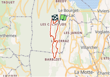

Length
10.6 km

Max alt
597 m

Uphill gradient
428 m
Km-Effort
16.3 km

Min alt
342 m

Downhill gradient
427 m
Boucle
Yes
Creation date :
2023-02-20 12:23:10.892
Updated on :
2023-02-20 15:34:56.752
3h11
Difficulty : Difficult

FREE GPS app for hiking
 SityTrail
IGN / Geographical institutes
SityTrail Plus
The world is yours!
About
Trail Walking of 10.6 km to be discovered at Auvergne-Rhône-Alpes, Savoy, Le Bourget-du-Lac. This trail is proposed by jljacquin.
Positioning
Country:
France
Region :
Auvergne-Rhône-Alpes
Department/Province :
Savoy
Municipality :
Le Bourget-du-Lac
Location:
Unknown
Start:(Dec)
Start:(UTM)
722023 ; 5057759 (31T) N.
Comments